Sierra Del Barón Rojo
The epics of my Beechcraft Sierra.Monday, July 10, 2006
Tamworth and Armidale 08-09 July 2006
The big trip, it was a toss-up between flying to Lightning Ridge or Tamworth Armidale.
Tamworth is a Class D airspace with Class C airspace above it. The Tamworth controller controls both airspaces from the tower frequency.
I have never flown into Tamworth before, and have only flown into the Albury Class-D airspace as part of my training. I have, however, flown into Bankstown several times, but it is a GAAP with special procedures.
Tamworth used to a simpler class-D airport only requiring a holding-point ready call, but now there is a NOTAM stating that Taxi Clearance is required, so it is a bit of a mixture. They also expect a departure report so that other traffic and the controller knows what you are doing. In fact, all through the area you hear departure reports from the non-towered aerodromes, however, you do not seem to hear them when departing Wagga Wagga, for example.
The trip up was over fairly friendly country with lots of places to land. I knew approximately where the airport was, but I couldn't see the runways, nor the tower until I got 4 nm away from R30R. What assisted greatly was that a Dash 8 was on final approach, so I got to follow that aircraft to the centre-line. Needless to say I asked for copious taxi instructions and I was shown the fuel bowsers and several access gates to leave the airside.
What was fairly interesting was that both tower frequencies were locked together and the tower controller was also the SMC.
The trip between Tamworth and Armidale was quite interesting because I had to climb at Vx to clear the range and climbed to 7500'. Uralla was directly on track and conveniently it is 10nm from Armidale making inbound calls very easy.
I have also not flown into Armidale's aerodrome but I was reasonably familiar with its location and orientation because I used to visit it. I spent 5 years in Armidale during my University days and have fond memories of the town. The main runway R23/15 is on top of an escarpment, and the runway itself is elevated slightly above the surrounding land - maybe to assist with drainage, but such a situation is a trap causing pilots to approach the threshold too low. R23 has PAPI lights which assist, and when you fly just north of the town at 5000' and aligned with the centreline you are right on the glideslope. Of course I do not have such long finals, but the Dash 8's do.
There was a southerly wind, and as you approach the threshold of R23 the wind is blowing down a slight downslope and then suddenly drops into the valley where Armidale lays. This causes a considerable amount of sink which requires more and more power on the approach until closer to the landing blocks. One way to avoid this is to be higher than the PAPI lights and to land further into the runway. To make matters worse the wind was a cross-wind as well, more inclined for R27 than for R23, however R27 is grass and a long way is a long way to taxi and backtrack along.
Well I visited my best man and his family and the next day I took the number 2 son over the Gorges near Armidale, a 36 minute flight, and my friend and his number 3 son on a city flight before departing for home.
I was delayed as I had a call of nature and then I decided to buy a chocolate, one of my vices, and I eventually got to leave at 0255. I had a severe headwind of 20 - 25 Kts so I decided that morning that I would fly directly from Armidale, to Nundle, cut-across the Tamworth Class C airspace (with permission) direct to Scone and thence direct to Canberra. The trip from Armidale to Nundle was over a fair bit of the great divide but there were several good looking flat spots I felt I could land in should I need to execute a forced landing. When I arrived at Scone there were quite a few paddocks and a good airstrip, but then I really hit the tiger country.
The country between Scone and Wallerawang is the worse country I have ever seen to fly over. On my direct track there was absolutely nowhere to land. I would have felt more comfortable had I tracked further to the west.
Here is a shot of Wolgan River in the tiger country that ripped from my video camera.
You can explore my tracks at Canberra, Tamworth Armidale
Armidale to the gorges near Hillgrove
Armidale Scone back to Canberra
Burning hours 03 Jul to 04 Jul
I needed to use up the remaining hours in order to perform the 25 hour oil change before the weekend because I was planning a long trip.
9 circuits were performed on 3 July, which used up 36 minutes.
One City Charlie (clockwise) 2 was flown for 13 minutes on the 3 July.
One City Alpha (anti-clockwise) 2 was flown twice for 28 minutes on the 4 July.
9 circuits were performed on 3 July, which used up 36 minutes.
One City Charlie (clockwise) 2 was flown for 13 minutes on the 3 July.
One City Alpha (anti-clockwise) 2 was flown twice for 28 minutes on the 4 July.
Sunday, July 02, 2006
Exercise at Merimbula - 1 Jul 2006
I needed to put about 4.5 hours on UMS before the next oil change and so I planned a trip to Merimbula and then Moruya as the weather was better in those directions, otherwise I would have headed North West to Parkes and then back via Wagga Wagga.
I left CB fairly late because I was waiting for the weather to break a little before I left home for the airport. Start permission was required for circuits and General Aviation aircraft, probably due to the volume of RPT traffic and the weather conditions.
The wind was quite interesting on takeoff from R35 comming from 290 degrees magnetic varying between 15 and 25 Kts (290/15G25), this is 60 degrees to the runway heading making the crosswind component of 13 to 22 Kts. R35 was used because R30/12 has not been available for a couple of months due to work in progress.
The flying conditions were not ideal with some turbulence being caused by wave conditions. While I was flying South East to Merimbula my Gliding compatriots were at Bunyan gliding field contacting wave.
I performed a right-hand circuit onto R03 at Meriumbula due to the prevailing wind conditions and local regulations: all circuits to the east.
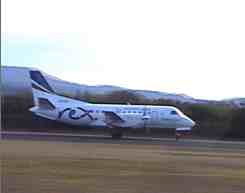
After landing I exited on the one and only taxi-way and had to turn past a Rex Saab that was about to embark on its journey. I tied UMS down on the grass using my ropes and sand-pegs I carry on board for such occassions, and I stood on the wing and videod the Saab's takeoff.
 A Rex Saab on takeoff roll.
Video of the Saab taking off.
The plan then was to walk into town for my weekly exercise, having decided that it was too much bother to carry my foldup bike onto the plane because it would involve two trips. For those who have travelled with me they will note that I carry a large flight bag and headset, a cooler bag that contains my Gell-Cell battery pack and GPS equipment, and usually a bag of supplies, which amounts to full hands.
The walking trip into town was interesting because one of the locals kept stopping their ute every 500 m and I walked passed them several times, but then I worked out that it was his young son riding a bicycle on the bike path I was using. I also passed several local pedestrians and other bike riders using the path for their exercise as well, including a grand-mother on a bike with her two grand-children on bikes, one of whom was on a tricycle.
It certainly would keep you fit going to and from town to the airport. The journey is not too long and the rewards of the restaurants and a good sea-food lunch are quite enticing.
I didn't have enough time left before last light to hang around for a snack so this time I walked to the bridge and crossed the road to the local garage to purchase an ice-cream and a bottle of ginger beer. Of course I walked that ice-cream off on the way back to the airport.
The next leg of the journey was to head to Moruya up the coast and over the ocean. I put my helicopter pilot's life vest on but I needn't have as I was always within gliding distance of the beaches. I almost flew over to Montague island and buzzed around but I was concerned with the time and prevailing conditions.
When I got to Moruya VH-VEZ was practicing circuits, a Cessna 441 twin. I overflew the airfield at 2,500' and positioned myself so I could watch a couple of takeoffs and landings. Due to the time factor I decided not to land and decided to head home, this saves me a few dollars in landing fees anyway.
The weather deteriorated with cloud base dropping from 7000' to 5000' near Braidwood.
I decided to decent to 4,500' to avoid cloud and to fly around Mt Pallerang ELEV 4146' to avoid most of the turbulence. I even thought that I might have to approach Canberra via the Burbong route but the cloud base lifted once I got closer to Bungendore.
Just after I received my airways clearance a medical emergency was declared on a Qantas RPT flight and I was set into orbit until instructed otherwise. The orbits just seemed to go for ever, and with the westerly wind I was swept back a nautical mile on each turn. Just like gliding but I wasn't allowed to change level.
When I was permitted to head to R35 the wind was 270/15G25 and it seemed to take forever to reach the threshold. Once I established white arc speed I looked at the GPS and it indicated 67 Kts - I was doing 90 Kts IAS. After deploying the gear and 15 degrees of flaps I was at 80 Kts indicated and it felt like I was just hanging in the air.
I yawed UMS into wind because it feels cool to do rather than drop the wing and fly with crossed-controls. I was careful to maintain my approach speed of 80 Kts on base and final. As I drew closer to the ground I maintained left ailerons, wings level and right rudder to straighten up, and back-pressure to keep the nose wheel high until the speed dropped off. This landing was better than my takeoff and UMS certainly has no trouble in this cross-wind. It is great to own and fly a low wing aircraft, and all that glider training has been very helpful with cross-wind and down-wind takeoff handling.
VH-UMS tracks for google earth.
I left CB fairly late because I was waiting for the weather to break a little before I left home for the airport. Start permission was required for circuits and General Aviation aircraft, probably due to the volume of RPT traffic and the weather conditions.
The wind was quite interesting on takeoff from R35 comming from 290 degrees magnetic varying between 15 and 25 Kts (290/15G25), this is 60 degrees to the runway heading making the crosswind component of 13 to 22 Kts. R35 was used because R30/12 has not been available for a couple of months due to work in progress.
The flying conditions were not ideal with some turbulence being caused by wave conditions. While I was flying South East to Merimbula my Gliding compatriots were at Bunyan gliding field contacting wave.
I performed a right-hand circuit onto R03 at Meriumbula due to the prevailing wind conditions and local regulations: all circuits to the east.
After landing I exited on the one and only taxi-way and had to turn past a Rex Saab that was about to embark on its journey. I tied UMS down on the grass using my ropes and sand-pegs I carry on board for such occassions, and I stood on the wing and videod the Saab's takeoff.
 A Rex Saab on takeoff roll.
Video of the Saab taking off.
The plan then was to walk into town for my weekly exercise, having decided that it was too much bother to carry my foldup bike onto the plane because it would involve two trips. For those who have travelled with me they will note that I carry a large flight bag and headset, a cooler bag that contains my Gell-Cell battery pack and GPS equipment, and usually a bag of supplies, which amounts to full hands.
The walking trip into town was interesting because one of the locals kept stopping their ute every 500 m and I walked passed them several times, but then I worked out that it was his young son riding a bicycle on the bike path I was using. I also passed several local pedestrians and other bike riders using the path for their exercise as well, including a grand-mother on a bike with her two grand-children on bikes, one of whom was on a tricycle.
It certainly would keep you fit going to and from town to the airport. The journey is not too long and the rewards of the restaurants and a good sea-food lunch are quite enticing.
I didn't have enough time left before last light to hang around for a snack so this time I walked to the bridge and crossed the road to the local garage to purchase an ice-cream and a bottle of ginger beer. Of course I walked that ice-cream off on the way back to the airport.
The next leg of the journey was to head to Moruya up the coast and over the ocean. I put my helicopter pilot's life vest on but I needn't have as I was always within gliding distance of the beaches. I almost flew over to Montague island and buzzed around but I was concerned with the time and prevailing conditions.
When I got to Moruya VH-VEZ was practicing circuits, a Cessna 441 twin. I overflew the airfield at 2,500' and positioned myself so I could watch a couple of takeoffs and landings. Due to the time factor I decided not to land and decided to head home, this saves me a few dollars in landing fees anyway.
The weather deteriorated with cloud base dropping from 7000' to 5000' near Braidwood.
I decided to decent to 4,500' to avoid cloud and to fly around Mt Pallerang ELEV 4146' to avoid most of the turbulence. I even thought that I might have to approach Canberra via the Burbong route but the cloud base lifted once I got closer to Bungendore.
Just after I received my airways clearance a medical emergency was declared on a Qantas RPT flight and I was set into orbit until instructed otherwise. The orbits just seemed to go for ever, and with the westerly wind I was swept back a nautical mile on each turn. Just like gliding but I wasn't allowed to change level.
When I was permitted to head to R35 the wind was 270/15G25 and it seemed to take forever to reach the threshold. Once I established white arc speed I looked at the GPS and it indicated 67 Kts - I was doing 90 Kts IAS. After deploying the gear and 15 degrees of flaps I was at 80 Kts indicated and it felt like I was just hanging in the air.
I yawed UMS into wind because it feels cool to do rather than drop the wing and fly with crossed-controls. I was careful to maintain my approach speed of 80 Kts on base and final. As I drew closer to the ground I maintained left ailerons, wings level and right rudder to straighten up, and back-pressure to keep the nose wheel high until the speed dropped off. This landing was better than my takeoff and UMS certainly has no trouble in this cross-wind. It is great to own and fly a low wing aircraft, and all that glider training has been very helpful with cross-wind and down-wind takeoff handling.
VH-UMS tracks for google earth.
Archives
April 2006 May 2006 June 2006 July 2006 June 2009
![]()
Subscribe to Posts [Atom]